Application of drones- archaeology
2017-09-19
 Drones in archaeology are being used more and more, as they can be used in many ways:
- aerial photography
- documentation
- mapping
- photogrammetry
This makes it possible save time and money, which are limited during archaeological excavations. More and more archaeological companies are acquiring drones, others are using qualified companies specializing in aerial photography. The following will describe the aforementioned types of drone applications by archaeologists.
Aerial photography and documentation
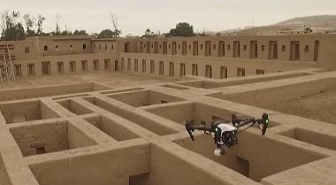
The first known photographs of archaeological sites that were taken from the air are from Rzucewo in 1929. Another comes from Biskupin (1935r.), which everyone has probably heard of; these photos were taken from a balloon. During the war period, archaeology did not develop. After World War II, helicopters began to be used, and in 1958 and 1959 the fields where the Battle of Grunwald took place were photographed with them. It should be noted that photographs taken from the air were used not only for documentation, to illustrate the whole, but also for field prospecting, otherwise known as surface surveys. They were intended to discover new sites that were much more visible from the air (a keen eye will spot anomalies in the landscape). These activities eventually led to the creation of a database of sites, the project was called Archaeological Imagery of Poland (it did not rely only on aerial photographs). It was and is an innovation in the world of archaeology, not only Polish, but also international. Unfortunately, due to the problems associated with the implementation of orders for aerial photography, i.e., the rental of a flying vehicle with a pilot and photographer, which was associated with high costs, as well as the fact that the pilot and photographer have little knowledge of archaeology so the photos left much to be desired; there was also a military-defense problem, namely, there was a ban on aerial photography, you had to obtain special permission. It was not until 1996 that the Archaeological Picture of Poland received funding to apply aerial photography fully to this project. In the last few years, one can observe a rapid development of this field, contributed to it by the emergence of the drones available to civilians.
Aerial photography and documentation are closely related, as aerial photos are one of the primary documentation materials at an archaeological site. If the site is small in size, or there are excavations on it alone, it can be photographed standing on a ladder, but this is unreliable because the perspective remains warped despite the height. We can use the drone to record the entire site/pit/excavation, these images are very helpful, m.in. at the stage of interpretation of the position. With photogrammetry, which will be discussed next, we go one step further because we can dispense with drawing documentation, which is quite time-consuming. In addition to what was mentioned above, aerial photography is used for aerial prospecting. New sites are sought, or the extent of those already known is checked; it is also possible to monitor whether a site is being rapidly depleted by natural processes and the human factor.
Mapping and photogrammetry
Just as documentation is linked to aerial photography itself, so mapping is linked to photogrammetry. Regarding the history of photogrammetry, I recommend the article: "Photogrammetry in Archaeology: Methodology and Uses, with Particular Regards to Accuracy." by Robert Barratt. Photogrammetry in archaeology has quite a few applications, namely: documentation of architectural monuments, archaeological excavations and individual monuments. This method saves time to be spent on field documentation and for excavation reports. As standard, the post takes "ladder" photos and drawings in scales (1:10; 1:20 are the most common). Drawings are made m.in. in order to know the exact dimensions of objects which cannot be obtained through photographs alone. Drawings are often time-consuming, and also require more people on the job. Photogrammetry allows us to reproduce objects in 2D or 3D, not flat drawings. Helpful for this is the application DroneDeploy.Which drone to use in archaeology?
As specialists in the subject of drones, based on our experience, we believe that the ideal products that will work well in archaeology are drones made by DJI. These products are distinguished by their high quality workmanship and ease of use. Many third-party applications useful in archaeology are compatible with DJI m drones.in the aforementioned DroneDeploy or Pix4D. In addition, the numerous range of accessories and products like bags and backpacks will make it easier for us to transport our equipment to hard-to-reach places. CONTACT US
Show more entries from
September 2017