DJI Zenmuse P1 + Care Enterprise
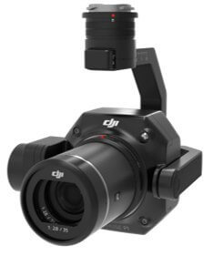
DJI Zenmuse P1 camera

The DJI P1 is a high-performance, versatile surveying camera made by DJI. The P1 integrated a full-frame 45-megapixel CMOS with 24mm, 35mm, and 50mm lens options, and a 3-axis stabilized gimbal. Combined with the M300 RTK platform and DJI Terra, the DJI P1 provides an efficient and precise aerial photogrammetry solution for enterprise customers. More than 5-10 times more efficient than the Phantom 4 RTK in ortho and oblique mapping missions.
The camera is only compatible with the DJI Matrice 300 RTK drone

The most important advantages of the P1 camera:
- Full frame CMOS sensor with a resolution of 45 megapixels
- Pixel size 4.4um
- Photo interval - 0.7 s
- TimeSync 2.0: Sync flight controller, RTK, gimbal and camera in milliseconds

Multiple lenses to choose from on the Zenmuse P1

The 35mm lens is suitable for most mapping scenarios. If the operating altitude of the UAV needed to be higher while maintaining the same resolution, the user would also have a 50mm lens option. Similarly, a 24mm lens would be available for lower altitude flights.
Mechanical global shutter, 1/2000s shutter speed
TimeSync 2.0: Millisecond-level synchronization with camera, gimbal, flight controller and RTK module
Supports DJI DL 24mm, 35mm and 50mm lens options
Ground sampling distance with different lens options:
24mm: GSD = H/55
35mm: GSD = H/80
50mm: GSD = H / 120
P4R for comparison: GSD=H/36.5
Drone camera for 3D mapping

- Smart Oblique Capture allows the P1 to achieve comparable performance in oblique mapping missions compared to oblique payloads with five lenses.
- Swing Motion Pattern: When the P1 is on a five-way diagonal mission, it swings in 5 directions at -60 degrees, when in the edge area, it only captures images inside the working area.
- High Efficiency of Oblique Action: During the flight, the P1 gimbal performs multi-angle shooting, greatly improving the efficiency of oblique action in a single-lens camera. The operational area with P1 can reach 7.5 square kilometers in just one day.[1]
- Necessary photo taking: Only photos necessary for construction are taken at the edges of the mapping, which will increase post-processing efficiency by 20%[2]-50%[3]。
- Comparison with oblique loading with five lenses: Fewer shots need to be taken
- Compared to a single camera payload: higher performance in diagonal missions
Assuming:
- [1] 3cm GSD, with front overlap ratio: 75% and side overlap ratio: 65%
- [2] 1.5Km 2 surveying area, flight height 200m
- [3] 0.5Km 2 Surveying aera, flight height 200m
New camera data management system
Intuitive, simple and smart photogrammetry workflow. All in one place to store images, GNSS data and log files. The relevant camera parameters, UAV parameters, which also include the current RTK status, are automatically saved in the image metadata. Automatically generated survey data folder by mission name and time.
User values:
- Ease of use: There will be no situation where the photo does not match the POS data, potentially resulting in a useless dataset.
- Highly Organized: no need to verify and organize POS image data, no need to manually modify datasets.
- Highly Integrated: information such as camera position, orientation position are saved in the captured image. Reconstructing from DJI Terra simply imports one folder and starts the process.
Field research report
- Field work report: After the flight mission is completed, a field inspection report is generated to quickly obtain information such as photo location, number of photos, RTK position status and location accuracy so that the pilot can confirm the quality of the field data on site.
- Real-time mapping: Working with DJI Terra for real-time mapping, the map will be generated while flying, which is what you get on the fly
- Cargo condition management system: logs total charge usage time, logs mechanical shutter and gimbal rotation usage times, and provides a historical log of system anomalies/faults and product maintenance suggestions.
The life of the P1 shutter is estimated at 100,000 times, maintenance is required after 100,000 times.

Many missions are possible with the DJI Zenmuse P1
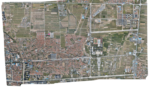
- 2D Orthophoto - In the scene of large-scale orthophoto operations, a highly integrated system, no GCP, and high-performance data collection, meeting 1:500 and 1:1000 cadastral accuracy standards
- 3D Oblique - Multi-angle oblique image data captured for 3D modeling is provided efficiently and concisely, which can be widely used in many industries, such as urban planning, cadastral surveying, security command, etc., helping you to make 3D realistic and build smart cities.
- Detailed Reconstruction - At a safe distance from the yard, high resolution data images can be effectively acquired to restore the fine texture, structure and properties of the ground and objects to a high degree. It can be widely used in the reconstruction of high-precision buildings, protection of ancient buildings/cultural monuments, water conservancy engineering and geological exploration, etc.
- Real-time Reconstruction - Connect with DJI Terra for real-time, large-area geographic information to help rescue sites
Zenmuse P1 camera parameters
Libra | 787g |
Dimensions | 198 x 166 x 129mm |
IP resistance | IP4X |
Supported platform | M300 RTK |
CMOS sensor size | 35.9 ×24mm |
Number of pixels | 45M |
Pixel size | 4.4um |
Supported SD cards | SD, Max Capacity: 128GB. Class 10 or UHS-1 recommended |
Resolution | 3:2 ( 8192×5460 ) |
Fastest interval | 0.7s |
Shutter Speed | Electronic Shutter Speed : 1/8000 - 8s Mechanical Shutter: 1/2000 - 1/8s |
Supported lenses | DJI DL 24mm F2.8 LS ASPH (with lens hood and balancing ring/filter), FOV 84° DJI DL 35mm F2.8 LS ASPH (with lens hood and balancing ring/filter), FOV 63.5° DJI DL 50mm F2.8 LS ASPH (with lens hood and balancing ring/filter), FOV 46.8° |
Modes of operation | Still Mode, Record Mode, Replay Mode |
Photo format | JPG, JPG+DNG 8192*5460 |
Photo resolution | 8192 x 5460 |
ISO | Photo: 100-25600 Video: 100-3200 |
Aperture range | f/2.8-f/16 |
Video resolution and parameters | 16:9 (3840×2160), 60FPS, MP4 |
mechanical range | Tilt: -125° to +40°; Roll: -55° to +55°; Pan: ±320° |
Specification DJI Zenmuse P1 + Care Enterprise
Entity responsible for this product in the EU
DJI Europe B.V.MoreProducerDJI Europe B.V.Address:
Bijdorp-Oost 6Postal code: 2992City: BarendrechtCountry: NetherlandsE-mail: dealer.nl@dji.com
Responsible entityDJI Europe B.V.Address:
Bijdorp-Oost 6Postal code: 2992City: BarendrechtCountry: NetherlandsE-mail: dealer.nl@dji.com
 Do you need help?Get expert adviceWe answer promptly, and make the most interesting questions available to everyone.
With drone photogrammetry, you will get data from the field faster and reduce operating costs.


