
Update and Maintenance Fee (DJI Terra Cluster Lifetime - 1 Set)

 Drone service
 Rental
 Reliability
 Trust
Trust Own warehouse
  Warranty
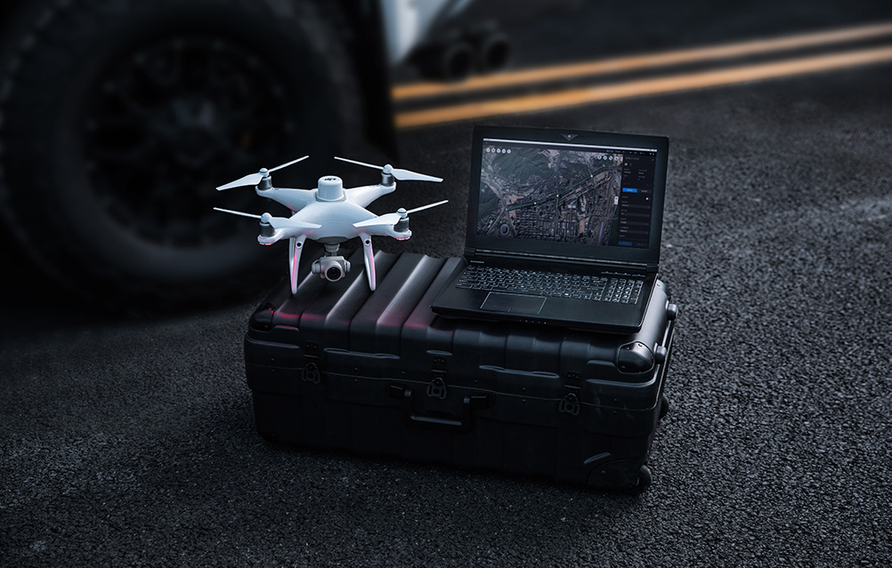
DJI Terra – use the world's potential to create digital assets
Capture, analyze and visualize your environment with DJI Terra - easy-to-use mapping software designed to help industry professionals turn real-world scenarios into digital assets.
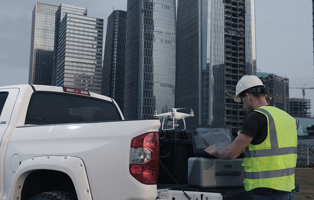
Many uses
DJI Terra software will work well in many professional applications:
- Construction – collect, measure and analyze data with the highest accuracy across a variety of projects.
- Infrastructure – Easily perform detailed inspections of complex facilities and structures.
- Energy – safe control of vertical elements and structures, with special optimizations for power lines.
- Public safety – minimize the time needed to collect critical information at the scene.
- Agriculture – detailed knowledge of the field will allow you to obtain higher yields.
- Filming – optimization of pre-visualization to improve planning processes across the entire team.
Create optimal flight routes
Use predefined waypoints and adjustable parameters such as altitude, speed, gimbal angle, flight course and much more. For more complex and difficult missions that require high attention to detail, use 3D flight visualization to design and simulate tasks on existing 3D models.

Automate complex missions
With just a few taps on the screen, you can automate complex missions. This will give you the ability to seamlessly capture images that can be processed to create a variety of maps and models for further analysis and decision-making assistance.
Plan missions in Oblique mode
When accuracy is essential and details are critical to your operations, Oblique allows you to capture a comprehensive set of 3D model data by adjusting the camera angle. This gives you an exceptionally clear view of the object.
Generate corridor missions
Create automated flight missions around roads and railways by simply drawing a line on the map. Customize mission settings to change the total area mapped - you can choose from options such as high resolution 2D maps, 3D models or quick views.
Plan detailed inspection missions
Automatically generate waypoints and flight paths from one or more points selected in a local 3D model or point cloud (or third-party point cloud). A simulated camera view of the selected point is displayed on screen to enable better landmark selection and more efficient flight path planning, automating the inspection flow.
Unrivaled comfort and efficiency of use
Import photos with ease by effortlessly navigating the intuitively designed interface. Batch process up to 400 photos per 1 GB of RAM, minimizing waiting time between field work and digital visualization. Complete reconstruction missions using multiple graphics cards simultaneously to increase performance.
Meet and exceed project standards
Generate highly detailed 2D orthomosaics and 3D models with increased absolute accuracy by setting terrain control points (GCPs) and control points. This will make it easier for you to take measurements and checks. View the Mission Quality Report to ensure results meet accuracy requirements.
Compatibility and functionality
Convert the coordinates of your maps and models to 8500+ principal coordinate systems by simply selecting the output that suits your needs. Also noteworthy is the incorporation of POS, GCP, or both data to create enhanced accuracy georeferenced maps and models directly in the target coordinate system required by the project.

Real-time mapping
Quickly generate a 2D orthomosaic of a selected area in real time. This is ideal for creating detailed flight paths in remote areas. It also proves to be extremely useful for missions where time is very short and quick on-the-spot decision-making is required.
2D reconstruction
Generate high-resolution orthomosaics. This way you can get detailed and accurate measurement results for all your key projects.
2D multispectral reconstruction
Using multispectral data from P4 Multispectral, generate radiometrically calibrated reflectance maps for remote sensing studies or vegetation index maps including NDVI and NDRE. Create recipe maps for variable fertilizer rates using DJI's Agras drones to increase yields while reducing costs.
Real-time 3D mapping
When performance is key, you can quickly render and visualize a 3D model of a designated area. Make decisions based on the initial model and immediately check its completeness or plan 3D flights on site.
3D reconstruction
Get sharp and realistic environments for a variety of professional applications such as accident reconstruction, recreating thin power lines and complex vertical structures, managing large construction projects, and more. CUDA-based reconstruction algorithms are able to quickly process large amounts of data, providing high-quality results. Moreover, with the Region of Interest function, image reconstruction can be performed for a specific target region. This, in turn, saves processing time and improves performance while generating a cleaner model or point cloud.

Data analysis
With easy-to-use analysis tools that enable you to obtain a variety of measurement data based on linear, area and volumetric measurements, you can obtain key dimensions in a variety of field conditions.
- Annotations – Edit measurement labels on existing models and use them for reporting and improving communication in ongoing projects.
- Photo Analysis – Carefully examine each model photo to identify and highlight all critical real-world elements.
Seamlessly connect to your DJI drone fleet
Use DJI Terra to plan and fly flights with the following models:
- Phantom 4 RTK,
- Phantom 4 Pro V2.0,
- Phantom 4 Pro + V2.0,
- Phantom 4 Pro,
- Phantom 4 Advanced,
- Phantom 4
Use DJI Terra to process data from:
- Phantom 4 (entire series),
- Zenmuse P1,
- Zenmuse L1,
- Zenmuse X7.
Types of DJI Terra license plans
Different types of DJI Terra licenses are available for sale (Online and Offline). Online License allows you to regularly connect your device to the Internet to verify eligibility and use paid features. Offline license allows you to use paid features without having to connect your devices to the Internet. However, it does not support unlocking GEO zones, loading maps and searching for locations. Additionally, without signing in to your DJI account, some flight control features in the DJI Terra app will be limited. Detailed information about each license plan can be found below.
| Functions | Agriculture version (Online) | Pro version (Online and Offline) | Electricity Version (Online) | Cluster version (Online) |
| Real-time 2D mapping | Yes | Yes | Yes | Yes |
| Application in agriculture | Yes | Yes | Yes | Yes |
| 2D reconstruction (fields) | Yes | Yes | Yes | Yes |
| Multispectral 2D reconstruction | Yes | Yes | Yes | Yes |
| 2D reconstruction (buildings) | - | Yes | Yes | Yes |
| Importing KML files | - | Yes | Yes | Yes |
| Output coordinate system | - | Yes | Yes | Yes |
| ROI (Return of Investment) reconstruction | - | Yes | Yes | Yes |
| Import of photos with POS data | - | Yes | Yes | Yes |
| Reconstruction using multiple graphics chips | - | Yes | Yes | Yes |
| 3D reconstruction | - | Yes | Yes | Yes |
| 3D mission planning | - | Yes | Yes | Yes |
| Real-time 3D mapping | - | Yes | Yes | Yes |
| GCP (Ground Control Points) data | - | Yes | Yes | Yes |
| Optimizing LiDAR point cloud accuracy | - | Yes | Yes | Yes |
| Application in energy | - | - | Yes | Yes |
| Detailed inspections | - | - | Yes | Yes |
Specification Update and Maintenance Fee (DJI Terra Cluster Lifetime - 1 Set)
 Get expert advice